


le ruisseau du Pousset

Mascart
User
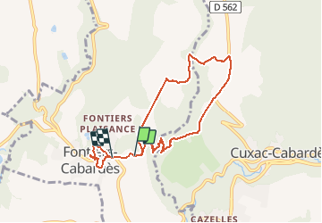

Length
8 km

Max alt
720 m

Uphill gradient
190 m
Km-Effort
10.6 km

Min alt
581 m

Downhill gradient
205 m
Boucle
No
Creation date :
2021-03-13 13:54:23.201
Updated on :
2021-03-13 16:13:48.776
2h01
Difficulty : Easy

FREE GPS app for hiking
 SityTrail
IGN / Geographical institutes
SityTrail Plus
The world is yours!
About
Trail Walking of 8 km to be discovered at Occitania, Aude, Fontiers-Cabardès. This trail is proposed by Mascart.
Description
via le centre équestre de Goutarende
Positioning
Country:
France
Region :
Occitania
Department/Province :
Aude
Municipality :
Fontiers-Cabardès
Location:
Unknown
Start:(Dec)
Start:(UTM)
439656 ; 4802196 (31T) N.
Comments