


que d'eau a 🤧

bendoush
User
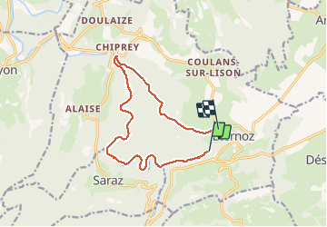

Length
12.6 km

Max alt
523 m

Uphill gradient
310 m
Km-Effort
16.5 km

Min alt
329 m

Downhill gradient
222 m
Boucle
No
Creation date :
2021-03-14 10:15:58.841
Updated on :
2021-03-14 13:54:52.662
3h35
Difficulty : Very easy

FREE GPS app for hiking
 SityTrail
IGN / Geographical institutes
SityTrail Plus
The world is yours!
About
Trail Walking of 12.6 km to be discovered at Bourgogne-Franche-Comté, Doubs, Éternoz. This trail is proposed by bendoush.
Positioning
Country:
France
Region :
Bourgogne-Franche-Comté
Department/Province :
Doubs
Municipality :
Éternoz
Location:
Éternoz
Start:(Dec)
Start:(UTM)
273575 ; 5209919 (32T) N.
Comments