


SityTrail - depart parking au dessus de barcelonnette rue des terrasses

gerardmicheline
User
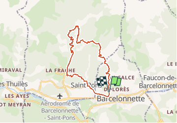

Length
14.5 km

Max alt
1656 m

Uphill gradient
831 m
Km-Effort
26 km

Min alt
1126 m

Downhill gradient
834 m
Boucle
Yes
Creation date :
2021-03-15 12:49:02.252
Updated on :
2021-03-15 13:18:15.162
5h48
Difficulty : Very difficult

FREE GPS app for hiking
 SityTrail
IGN / Geographical institutes
SityTrail Plus
The world is yours!
About
Trail Walking of 14.5 km to be discovered at Provence-Alpes-Côte d'Azur, Alpes-de-Haute-Provence, Barcelonnette. This trail is proposed by gerardmicheline.
Positioning
Country:
France
Region :
Provence-Alpes-Côte d'Azur
Department/Province :
Alpes-de-Haute-Provence
Municipality :
Barcelonnette
Location:
Unknown
Start:(Dec)
Start:(UTM)
312271 ; 4917828 (32T) N.
Comments