


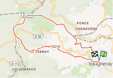
69 Vaugneray Col de Malval

trietsch
User

Length
10.3 km

Max alt
787 m

Uphill gradient
384 m
Km-Effort
15.4 km

Min alt
412 m

Downhill gradient
388 m
Boucle
Yes
Creation date :
2021-03-16 06:41:25.913
Updated on :
2021-03-16 07:04:02.835
3h30
Difficulty : Easy
4h02
Difficulty : Difficult

FREE GPS app for hiking
 SityTrail
IGN / Geographical institutes
SityTrail Plus
The world is yours!
About
Trail On foot of 10.3 km to be discovered at Auvergne-Rhône-Alpes, Rhône, Vaugneray. This trail is proposed by trietsch.
Positioning
Country:
France
Region :
Auvergne-Rhône-Alpes
Department/Province :
Rhône
Municipality :
Vaugneray
Location:
Vaugneray
Start:(Dec)
Start:(UTM)
628918 ; 5066336 (31T) N.
Comments