


69 vaugnerai telle

trietsch
User
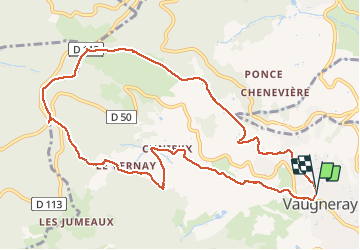

Length
11.4 km

Max alt
787 m

Uphill gradient
405 m
Km-Effort
16.8 km

Min alt
412 m

Downhill gradient
400 m
Boucle
Yes
Creation date :
2021-03-16 08:42:40.0
Updated on :
2021-03-16 12:36:03.345
2h57
Difficulty : Unknown

FREE GPS app for hiking
 SityTrail
IGN / Geographical institutes
SityTrail Plus
The world is yours!
About
Trail Walking of 11.4 km to be discovered at Auvergne-Rhône-Alpes, Rhône, Vaugneray. This trail is proposed by trietsch.
Positioning
Country:
France
Region :
Auvergne-Rhône-Alpes
Department/Province :
Rhône
Municipality :
Vaugneray
Location:
Vaugneray
Start:(Dec)
Start:(UTM)
628912 ; 5066364 (31T) N.
Comments