


fons sur Lussan serres de fons

Dan30
User
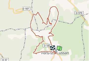

Length
12.9 km

Max alt
470 m

Uphill gradient
264 m
Km-Effort
16.4 km

Min alt
291 m

Downhill gradient
264 m
Boucle
Yes
Creation date :
2021-03-16 09:11:25.11
Updated on :
2021-03-16 14:28:14.812
4h42
Difficulty : Easy

FREE GPS app for hiking
 SityTrail
IGN / Geographical institutes
SityTrail Plus
The world is yours!
About
Trail Walking of 12.9 km to be discovered at Occitania, Gard, Fons-sur-Lussan. This trail is proposed by Dan30.
Photos


Positioning
Country:
France
Region :
Occitania
Department/Province :
Gard
Municipality :
Fons-sur-Lussan
Location:
Unknown
Start:(Dec)
Start:(UTM)
606318 ; 4893247 (31T) N.
Comments