


voie verte vigan

Bwattier
User

Length
6.8 km

Max alt
358 m

Uphill gradient
228 m
Km-Effort
9.8 km

Min alt
265 m

Downhill gradient
227 m
Boucle
Yes
Creation date :
2021-03-16 14:22:28.328
Updated on :
2021-03-16 16:01:44.894
1h39
Difficulty : Very easy

FREE GPS app for hiking
 SityTrail
IGN / Geographical institutes
SityTrail Plus
The world is yours!
About
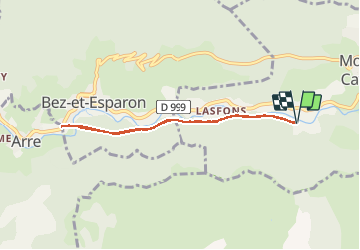
Trail Walking of 6.8 km to be discovered at Occitania, Gard, Molières-Cavaillac. This trail is proposed by Bwattier.
Positioning
Country:
France
Region :
Occitania
Department/Province :
Gard
Municipality :
Molières-Cavaillac
Location:
Unknown
Start:(Dec)
Start:(UTM)
545371 ; 4868534 (31T) N.
Comments