


parcelle ay 188 fond budan baie mahault

SAFER
User
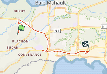

Length
8.2 km

Max alt
36 m

Uphill gradient
89 m
Km-Effort
9.5 km

Min alt
3 m

Downhill gradient
100 m
Boucle
No
Creation date :
2021-03-17 12:21:08.355
Updated on :
2021-03-17 14:07:10.235
1h18
Difficulty : Very easy

FREE GPS app for hiking
 SityTrail
IGN / Geographical institutes
SityTrail Plus
The world is yours!
About
Trail Other activity of 8.2 km to be discovered at Guadeloupe, Unknown, Baie-Mahault. This trail is proposed by SAFER.
Description
piperol
Positioning
Country:
France
Region :
Guadeloupe
Department/Province :
Unknown
Municipality :
Baie-Mahault
Location:
Unknown
Start:(Dec)
Start:(UTM)
648948 ; 1797099 (20Q) N.
Comments