


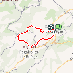
Peyre Martine au départ de Saint de Buèges

ARVIEU
User

Length
13.1 km

Max alt
772 m

Uphill gradient
706 m
Km-Effort
22 km

Min alt
156 m

Downhill gradient
705 m
Boucle
Yes
Creation date :
2015-10-01 00:00:00.0
Updated on :
2015-10-01 00:00:00.0
4h38
Difficulty : Medium

FREE GPS app for hiking
 SityTrail
IGN / Geographical institutes
SityTrail Plus
The world is yours!
About
Trail Walking of 13.1 km to be discovered at Occitania, Hérault, Saint-Jean-de-Buèges. This trail is proposed by ARVIEU.
Description
Peyre Martine au départ de Saint Jean de Buèges en passant par la source de la Buèges au Méjanel
Positioning
Country:
France
Region :
Occitania
Department/Province :
Hérault
Municipality :
Saint-Jean-de-Buèges
Location:
Unknown
Start:(Dec)
Start:(UTM)
549716 ; 4852607 (31T) N.
Comments