Trail Walking Baincthun - SityTrail - Sentier de la Pierre de Baincthun - Photo

SityTrail - Sentier de la Pierre de Baincthun

 tenace
tenace

User

© OpenStreetMap contributors
Length
Length
4.6 km
Max alt
Max alt
141 m
Uphill gradient
Uphill gradient
86 m
Km-Effort
Km-Effort  
5.8 km
Min alt
Min alt
74 m
Downhill gradient
Downhill gradient
87 m
Boucle
Boucle
Yes
Creation date :
2021-03-17 22:47:10.422
Updated on :
2021-03-17 23:12:43.238

(0 Reviews)

Walking
Walking
1h18
Difficulty : Easy

Scan this QR Code to open this trail in the SityTrail application

FREE GPS app for hiking

Logo SityTrail SityTrail

IGN / Geographical institutes

Download SityTrail from the App Store Download SityTrail from Google Play

Logo SityTrail SityTrail Plus

The world is yours!

Download SityTrail from the App Store Download SityTrail from Google Play Download SityTrail on Huawei AppGallery

About

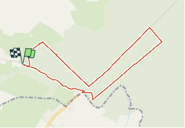
Trail Walking of 4.6 km to be discovered at Hauts-de-France, Pas-de-Calais, Baincthun. This trail is proposed by tenace.

Description

Départ du parking de l’église de Baincthun. Le sentier permet de découvrir de très beaux panoramas sur les célèbres monts du Boulonnais. Entre autres : le Mont Lambert, le Mont d’Herquelingue. Vous pourrez également découvrir une construction récente : le viaduc d’Echinghen, construit sur un sol bien particulier composé de calcaire, d’argile et de sable. Retrouvez le circuit sur le site l’agglomération du Boulonnais.

Elevation profile

Positioning

Country:
France
Region :
Hauts-de-France
Department/Province :
Pas-de-Calais
Municipality :
Baincthun
Location:
Unknown
Start:(UTM)
407437 ; 5615740 (31U) N.


Close
My subscriptions