


Col d'Ey-Linceuil-Milmandre-Ey

lionelnottat
User
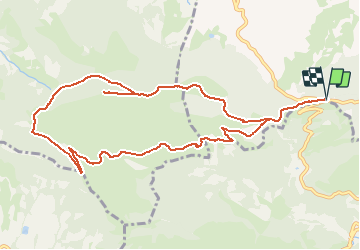

Length
12 km

Max alt
1177 m

Uphill gradient
596 m
Km-Effort
20 km

Min alt
651 m

Downhill gradient
596 m
Boucle
Yes
Creation date :
2021-03-18 16:10:35.824
Updated on :
2021-03-18 16:12:09.509
4h32
Difficulty : Very difficult

FREE GPS app for hiking
 SityTrail
IGN / Geographical institutes
SityTrail Plus
The world is yours!
About
Trail Walking of 12 km to be discovered at Auvergne-Rhône-Alpes, Drôme, Sainte-Jalle. This trail is proposed by lionelnottat.
Positioning
Country:
France
Region :
Auvergne-Rhône-Alpes
Department/Province :
Drôme
Municipality :
Sainte-Jalle
Location:
Unknown
Start:(Dec)
Start:(UTM)
681652 ; 4909127 (31T) N.
Comments