


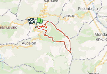
Le Deves (Pennes le Sec)

ajd26
User

Length
13.2 km

Max alt
1316 m

Uphill gradient
586 m
Km-Effort
21 km

Min alt
856 m

Downhill gradient
590 m
Boucle
Yes
Creation date :
2021-03-18 08:12:48.0
Updated on :
2023-03-03 09:49:47.589
3h49
Difficulty : Medium

FREE GPS app for hiking
 SityTrail
IGN / Geographical institutes
SityTrail Plus
The world is yours!
About
Trail Walking of 13.2 km to be discovered at Auvergne-Rhône-Alpes, Drôme, Aucelon. This trail is proposed by ajd26.
Description
Depuis le Deves, montée sur les crêtes, pas de Jansac (pylône) avec très beaux panoramas sur le Diois et le sud
Positioning
Country:
France
Region :
Auvergne-Rhône-Alpes
Department/Province :
Drôme
Municipality :
Aucelon
Location:
Unknown
Start:(Dec)
Start:(UTM)
686651 ; 4945395 (31T) N.
Comments