


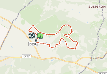
Fontvielle Le Château d'Estoublon et le mont Paon 8,6 km

jacky rahir
User

Length
8.6 km

Max alt
189 m

Uphill gradient
180 m
Km-Effort
11 km

Min alt
46 m

Downhill gradient
182 m
Boucle
Yes
Creation date :
2021-03-19 14:01:08.612
Updated on :
2021-03-19 14:03:06.536
2h29
Difficulty : Medium

FREE GPS app for hiking
 SityTrail
IGN / Geographical institutes
SityTrail Plus
The world is yours!
About
Trail Walking of 8.6 km to be discovered at Provence-Alpes-Côte d'Azur, Bouches-du-Rhône, Fontvieille. This trail is proposed by jacky rahir.
Positioning
Country:
France
Region :
Provence-Alpes-Côte d'Azur
Department/Province :
Bouches-du-Rhône
Municipality :
Fontvieille
Location:
Unknown
Start:(Dec)
Start:(UTM)
639719 ; 4843982 (31T) N.
Comments