![](/images/other/stat-length.png)
![Trail Walking Genappe - ABN - Bousval - Bois des Conins - Cala - Photo](https://media.geolcdn.com/t/1900/400/ext.pjpeg?maxdim=2&url=https%3A%2F%2Fstatic1.geolcdn.com%2Fsiteimages%2Fupload%2Ffiles%2F1553511878bg_sport_marche.png)
ABN - Bousval - Bois des Conins - Cala
samlrando
User
![Length](/images/other/stat-length.png)
Length
7.4 km
![Max alt](https://static1.geolcdn.com/siteimages/upload/files/1508320355ic_sort_altitude_max_24dp.png)
Max alt
142 m
![Uphill gradient](https://static1.geolcdn.com/siteimages/upload/files/1508320355ic_sort_den_pos_24dp.png)
Uphill gradient
168 m
![Km-Effort](/images/other/stat-length.png)
Km-Effort
9.6 km
![Min alt](https://static1.geolcdn.com/siteimages/upload/files/1508320355ic_sort_altitude_min_24dp.png)
Min alt
73 m
![Downhill gradient](https://static1.geolcdn.com/siteimages/upload/files/1508320355ic_sort_den_neg_24dp.png)
Downhill gradient
169 m
![Boucle](https://static1.geolcdn.com/siteimages/upload/files/16400158638029165_repeat_loop_refresh_sync_direction_icon.png)
Boucle
Yes
Creation date :
2021-03-20 09:46:40.0
Updated on :
2021-03-23 11:12:42.978
![Walking](https://static1.geolcdn.com/sitytour/trail-icons/101.png)
1h45
Difficulty : Unknown
![Scan this QR Code to open this trail in the SityTrail application](https://capi.geolives.com/qq0zvz2zws4bq2lad0pu/sitytour/trails/2713816/qr.png?size=200)
FREE GPS app for hiking
About
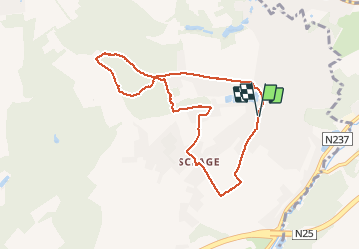
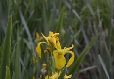
Trail Walking of 7.4 km to be discovered at Wallonia, Walloon Brabant, Genappe. This trail is proposed by samlrando.
Description
Très joli parcours, très mouillé/boueux voire plus après le ponceau pour passer la Cala, surtout après quelques jours de pluie. Quelques dénivellés marqués.
Positioning
Country:
Belgium
Region :
Wallonia
Department/Province :
Walloon Brabant
Municipality :
Genappe
Location:
Bousval
Start:(Dec)
Start:(UTM)
607880 ; 5610628 (31U) N.
Comments
Trails nearby
![Trail Walking Genappe - RB-Bw-09 Raccourci 1 & 2 - Autour de la jeune Dyle et de ses affluents - Photo](https://media.geolcdn.com/t/375/260/ext.jpg?maxdim=2&url=https%3A%2F%2Fservices.sitytrail.com%2FGeolivesWS%2FDownloadMedia.ashx%3FTrailID%3D220340%26Media%3Dd40b4c5b-4793-41f9-ac7b-fe40a955ea25.jpg)
![Walking Walking](https://static1.geolcdn.com/sitytour/trail-icons/101.png)
RB-Bw-09 Raccourci 1 & 2 - Autour de la jeune Dyle et de ses affluents
Walking
Difficult
(11)
Genappe,
Wallonia,
Walloon Brabant,
Belgium
![](/images/other/stat-length.png)
9.7 km | 12.5 km-effort
2h 50min
![](https://static1.geolcdn.com/siteimages/upload/files/16400158638029165_repeat_loop_refresh_sync_direction_icon.png)
Yes
![Trail Walking Genappe - RB-Bw-09 Raccourci 1 - Autour de la jeune Dyle et de ses affluents - Photo](https://media.geolcdn.com/t/375/260/ext.jpg?maxdim=2&url=https%3A%2F%2Fservices.sitytrail.com%2FGeolivesWS%2FDownloadMedia.ashx%3FTrailID%3D220337%26Media%3Dcacfbcff-3084-47a0-8267-9fc97c2da542.jpg)
![Walking Walking](https://static1.geolcdn.com/sitytour/trail-icons/101.png)
RB-Bw-09 Raccourci 1 - Autour de la jeune Dyle et de ses affluents
Walking
Difficult
(11)
Genappe,
Wallonia,
Walloon Brabant,
Belgium
![](/images/other/stat-length.png)
13.2 km | 16.9 km-effort
3h 49min
![](https://static1.geolcdn.com/siteimages/upload/files/16400158638029165_repeat_loop_refresh_sync_direction_icon.png)
Yes
![Trail Walking Genappe - RB-Bw-09 - Autour de la jeune Dyle et de ses affluents - Photo](https://media.geolcdn.com/t/375/260/ext.jpg?maxdim=2&url=https%3A%2F%2Fservices.sitytrail.com%2FGeolivesWS%2FDownloadMedia.ashx%3FTrailID%3D179584%26Media%3Dd40b4c5b-4793-41f9-ac7b-fe40a955ea25.jpg)
![Walking Walking](https://static1.geolcdn.com/sitytour/trail-icons/101.png)
RB-Bw-09 - Autour de la jeune Dyle et de ses affluents
Walking
Medium
(9)
Genappe,
Wallonia,
Walloon Brabant,
Belgium
![](/images/other/stat-length.png)
22 km | 28 km-effort
5h 59min
![](https://static1.geolcdn.com/siteimages/upload/files/16400158638029165_repeat_loop_refresh_sync_direction_icon.png)
Yes
![Trail Walking Court-Saint-Étienne - GG2-Bw-22_La-Roche-Blanmont_2021-11-04 - Photo](https://media.geolcdn.com/t/375/260/ext.jpg?maxdim=2&url=https%3A%2F%2Fmedia.geolcdn.com%2Ff%2F2a6f461f-efef-416e-b536-c468aeb7dc39.jpg)
![Walking Walking](https://static1.geolcdn.com/sitytour/trail-icons/101.png)
GG2-Bw-22_La-Roche-Blanmont_2021-11-04
Walking
Medium
(2)
Court-Saint-Étienne,
Wallonia,
Walloon Brabant,
Belgium
![](/images/other/stat-length.png)
21 km | 26 km-effort
5h 51min
![](https://static1.geolcdn.com/siteimages/upload/files/16400158638029165_repeat_loop_refresh_sync_direction_icon.png)
No
![Trail Walking Ottignies-Louvain-la-Neuve - GG-Bw-02_Céroux-Mousty - Villers-la-Ville - Photo](https://media.geolcdn.com/t/375/260/ext.jpg?maxdim=2&url=https%3A%2F%2Fmedia.geolcdn.com%2Ff%2F9dc1100d-f11d-446a-a492-1a8c831ce762.jpg)
![Walking Walking](https://static1.geolcdn.com/sitytour/trail-icons/101.png)
GG-Bw-02_Céroux-Mousty - Villers-la-Ville
Walking
Very difficult
(2)
Ottignies-Louvain-la-Neuve,
Wallonia,
Walloon Brabant,
Belgium
![](/images/other/stat-length.png)
20 km | 26 km-effort
5h 37min
![](https://static1.geolcdn.com/siteimages/upload/files/16400158638029165_repeat_loop_refresh_sync_direction_icon.png)
No
![Trail Mountain bike Lasne - maransart - Photo](https://media.geolcdn.com/t/375/260/ext.jpg?maxdim=2&url=https%3A%2F%2Fmedia.geolcdn.com%2Ff%2F7952ab46-ca6a-430d-9a36-3ac3fa120ed7.JPG)
![Mountain bike Mountain bike](https://static1.geolcdn.com/sitytour/trail-icons/202.png)
maransart
Mountain bike
Difficult
(1)
Lasne,
Wallonia,
Walloon Brabant,
Belgium
![](/images/other/stat-length.png)
40 km | 49 km-effort
Unknown
![](https://static1.geolcdn.com/siteimages/upload/files/16400158638029165_repeat_loop_refresh_sync_direction_icon.png)
Yes
![Trail Walking Ottignies-Louvain-la-Neuve - Lauzelle - Circuit Natura 2000, des sites qui valent le détour ! - Bw01 - Photo](https://media.geolcdn.com/t/375/260/ext.jpg?maxdim=2&url=https%3A%2F%2Fmedia.geolcdn.com%2Ff%2F648550f3-d9ef-4b6f-9933-939a57e593f5.JPG)
![Walking Walking](https://static1.geolcdn.com/sitytour/trail-icons/101.png)
Lauzelle - Circuit Natura 2000, des sites qui valent le détour ! - Bw01
Walking
Easy
(2)
Ottignies-Louvain-la-Neuve,
Wallonia,
Walloon Brabant,
Belgium
![](/images/other/stat-length.png)
3.8 km | 4.8 km-effort
1h 26min
![](https://static1.geolcdn.com/siteimages/upload/files/16400158638029165_repeat_loop_refresh_sync_direction_icon.png)
Yes
![Trail Walking Court-Saint-Étienne - RB-BW-08 - À la rencontre de trois vallées - Photo](https://media.geolcdn.com/t/375/260/ext.jpg?maxdim=2&url=https%3A%2F%2Fservices.sitytrail.com%2FGeolivesWS%2FDownloadMedia.ashx%3FTrailID%3D220267%26Media%3D6c86831f-6220-45af-ac63-82e6ea37f2ed.jpg)
![Walking Walking](https://static1.geolcdn.com/sitytour/trail-icons/101.png)
RB-BW-08 - À la rencontre de trois vallées
Walking
Very difficult
(2)
Court-Saint-Étienne,
Wallonia,
Walloon Brabant,
Belgium
![](/images/other/stat-length.png)
26 km | 32 km-effort
7h 18min
![](https://static1.geolcdn.com/siteimages/upload/files/16400158638029165_repeat_loop_refresh_sync_direction_icon.png)
Yes
![Trail Walking Court-Saint-Étienne - #240304 - La Roche, bois Ste Catherine et du Sartage - Photo](https://media.geolcdn.com/t/375/260/ext.jpg?maxdim=2&url=https%3A%2F%2Fmedia.geolcdn.com%2Ff%2Fd185017a-b96f-406a-b9d2-c4084024f2c7.jpg)
![Walking Walking](https://static1.geolcdn.com/sitytour/trail-icons/101.png)
#240304 - La Roche, bois Ste Catherine et du Sartage
Walking
Medium
(1)
Court-Saint-Étienne,
Wallonia,
Walloon Brabant,
Belgium
![](/images/other/stat-length.png)
5.8 km | 7.6 km-effort
1h 42min
![](https://static1.geolcdn.com/siteimages/upload/files/16400158638029165_repeat_loop_refresh_sync_direction_icon.png)
Yes