


JFT YB Etape2 28-4 -2014

jeff2
User
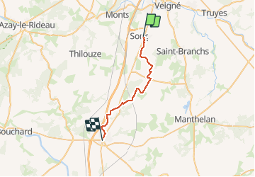

Length
25 km

Max alt
133 m

Uphill gradient
139 m
Km-Effort
27 km

Min alt
69 m

Downhill gradient
163 m
Boucle
No
Creation date :
2014-12-10 00:00:00.0
Updated on :
2014-12-10 00:00:00.0
6h10
Difficulty : Easy

FREE GPS app for hiking
 SityTrail
IGN / Geographical institutes
SityTrail Plus
The world is yours!
About
Trail Walking of 25 km to be discovered at Centre-Loire Valley, Indre-et-Loire, Sorigny. This trail is proposed by jeff2.
Description
Sorigny St maure de Touraine
Photos


Positioning
Country:
France
Region :
Centre-Loire Valley
Department/Province :
Indre-et-Loire
Municipality :
Sorigny
Location:
Unknown
Start:(Dec)
Start:(UTM)
325445 ; 5235023 (31T) N.
Comments