


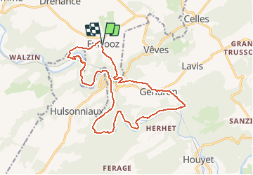
Furfooz-Gendron-Aiguilles de chaleux

geoffrayLayeux
User

Length
16.7 km

Max alt
232 m

Uphill gradient
421 m
Km-Effort
22 km

Min alt
99 m

Downhill gradient
416 m
Boucle
Yes
Creation date :
2021-03-20 16:46:06.874
Updated on :
2021-03-20 17:01:45.516
5h03
Difficulty : Very difficult

FREE GPS app for hiking
 SityTrail
IGN / Geographical institutes
SityTrail Plus
The world is yours!
About
Trail Walking of 16.7 km to be discovered at Wallonia, Namur, Dinant. This trail is proposed by geoffrayLayeux.

Positioning
Country:
Belgium
Region :
Wallonia
Department/Province :
Namur
Municipality :
Dinant
Location:
Furfooz
Start:(Dec)
Start:(UTM)
639812 ; 5565248 (31U) N.
Comments