


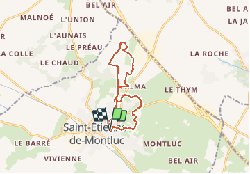
Saint Étienne de Montluc - 12 km

Lobin
User

Length
11.5 km

Max alt
87 m

Uphill gradient
110 m
Km-Effort
13 km

Min alt
23 m

Downhill gradient
110 m
Boucle
Yes
Creation date :
2021-03-20 13:02:56.0
Updated on :
2021-03-20 20:33:57.318
2h00
Difficulty : Medium

FREE GPS app for hiking
 SityTrail
IGN / Geographical institutes
SityTrail Plus
The world is yours!
About
Trail Walking of 11.5 km to be discovered at Pays de la Loire, Loire-Atlantique, Saint-Étienne-de-Montluc. This trail is proposed by Lobin.
Photos

Positioning
Country:
France
Region :
Pays de la Loire
Department/Province :
Loire-Atlantique
Municipality :
Saint-Étienne-de-Montluc
Location:
Unknown
Start:(Dec)
Start:(UTM)
592714 ; 5236454 (30T) N.
Comments