


Ox Prtelebe fait mars 2021

pidjam
User
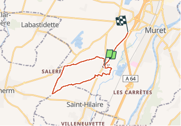

Length
11.5 km

Max alt
199 m

Uphill gradient
58 m
Km-Effort
12.3 km

Min alt
173 m

Downhill gradient
72 m
Boucle
No
Creation date :
2021-03-21 12:57:29.721
Updated on :
2021-03-21 15:15:29.461
2h17
Difficulty : Very easy

FREE GPS app for hiking
 SityTrail
IGN / Geographical institutes
SityTrail Plus
The world is yours!
About
Trail Walking of 11.5 km to be discovered at Occitania, Haute-Garonne, Muret. This trail is proposed by pidjam.
Positioning
Country:
France
Region :
Occitania
Department/Province :
Haute-Garonne
Municipality :
Muret
Location:
Unknown
Start:(Dec)
Start:(UTM)
361719 ; 4811347 (31T) N.
Comments