


dagneux 7.9 a 131- 21 03 21

jtraverse
User
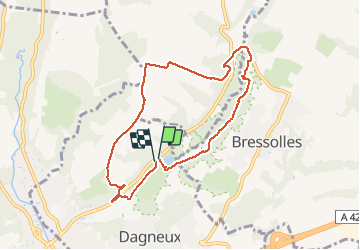

Length
7.8 km

Max alt
286 m

Uphill gradient
139 m
Km-Effort
9.7 km

Min alt
214 m

Downhill gradient
141 m
Boucle
Yes
Creation date :
2021-03-22 12:09:37.596
Updated on :
2021-03-22 14:09:57.321
1h59
Difficulty : Very easy

FREE GPS app for hiking
 SityTrail
IGN / Geographical institutes
SityTrail Plus
The world is yours!
About
Trail Walking of 7.8 km to be discovered at Auvergne-Rhône-Alpes, Ain, Dagneux. This trail is proposed by jtraverse.
Positioning
Country:
France
Region :
Auvergne-Rhône-Alpes
Department/Province :
Ain
Municipality :
Dagneux
Location:
Unknown
Start:(Dec)
Start:(UTM)
661186 ; 5080974 (31T) N.
Comments