


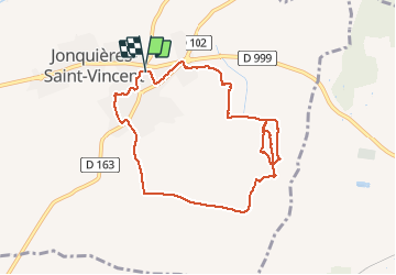
Jonquières – Moulin – Clos Argent

rando30129
User

Length
8.8 km

Max alt
63 m

Uphill gradient
94 m
Km-Effort
10.1 km

Min alt
18 m

Downhill gradient
96 m
Boucle
Yes
Creation date :
2021-03-23 12:26:35.431
Updated on :
2025-01-13 21:03:38.469
2h17
Difficulty : Medium

FREE GPS app for hiking
 SityTrail
IGN / Geographical institutes
SityTrail Plus
The world is yours!
About
Trail Walking of 8.8 km to be discovered at Occitania, Gard, Jonquières-Saint-Vincent. This trail is proposed by rando30129.
Positioning
Country:
France
Region :
Occitania
Department/Province :
Gard
Municipality :
Jonquières-Saint-Vincent
Location:
Unknown
Start:(Dec)
Start:(UTM)
625755 ; 4854139 (31T) N.
Comments