


gpx-trace

Renefrt
User
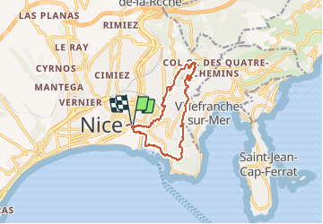

Length
13.5 km

Max alt
352 m

Uphill gradient
466 m
Km-Effort
19.7 km

Min alt
2 m

Downhill gradient
466 m
Boucle
Yes
Creation date :
2021-03-24 10:03:44.0
Updated on :
2021-05-09 19:03:09.296
4h28
Difficulty : Medium

FREE GPS app for hiking
 SityTrail
IGN / Geographical institutes
SityTrail Plus
The world is yours!
About
Trail Walking of 13.5 km to be discovered at Provence-Alpes-Côte d'Azur, Maritime Alps, Nice. This trail is proposed by Renefrt.
Positioning
Country:
France
Region :
Provence-Alpes-Côte d'Azur
Department/Province :
Maritime Alps
Municipality :
Nice
Location:
Unknown
Start:(Dec)
Start:(UTM)
361476 ; 4840088 (32T) N.
Comments