Trail Walking Saint-Christophe-Vallon - Le Puech du Cayla  - Photo
 ZITO12
ZITO12

User

© OpenStreetMap contributors
Length
Length
11.5 km
Max alt
Max alt
540 m
Uphill gradient
Uphill gradient
313 m
Km-Effort
Km-Effort  
15.7 km
Min alt
Min alt
312 m
Downhill gradient
Downhill gradient
314 m
Boucle
Boucle
Yes
Creation date :
2021-03-24 08:24:53.158
Updated on :
2021-03-24 13:25:32.504

(0 Reviews)

Walking
Walking
4h59
Difficulty : Very easy

Scan this QR Code to open this trail in the SityTrail application

FREE GPS app for hiking

Logo SityTrail SityTrail

IGN / Geographical institutes

Download SityTrail from the App Store Download SityTrail from Google Play

Logo SityTrail SityTrail World

The world is yours!

Download SityTrail from the App Store Download SityTrail from Google Play Download SityTrail on Huawei AppGallery

About

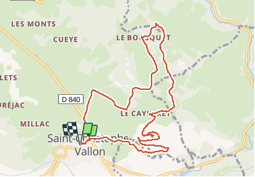
Trail Walking of 11.5 km to be discovered at Occitania, Aveyron, Saint-Christophe-Vallon. This trail is proposed by ZITO12.

Description

Rando très facile avec de belles vues panoramiques. Beaucoup de passages en situation dominante. Petit bémol : un peu trop de goudron au départ mais sans circulation. Beaucoup de chants d'oiseaux au printemps.

Elevation profile

Photos

Positioning

Country:
France
Region :
Occitania
Department/Province :
Aveyron
Municipality :
Saint-Christophe-Vallon
Location:
Unknown
Start:(UTM)
453036 ; 4924196 (31T) N.

Trails nearby

Trail Walking Clairvaux-d'Aveyron - Clairvaux les vignes  - Photo
Walking
ZITO12

Walking

Medium
Clairvaux-d'Aveyron, Occitania, Aveyron, France
11.7 km | 17.7 km-effort
3h 34min
Yes
Trail On foot Marcillac-Vallon - De la Vigne à la Forêt - Photo
On foot
PRO

On foot

Easy
Marcillac-Vallon, Occitania, Aveyron, France
10.1 km | 14.1 km-effort
3h 11min
Yes
Trail On foot Clairvaux-d'Aveyron - Le Puech du Puot - Photo
On foot
PRO

On foot

Easy
Clairvaux-d'Aveyron, Occitania, Aveyron, France
11.3 km | 16 km-effort
3h 38min
No
Trail On foot Marcillac-Vallon - Le Puech du Cayla - Photo
On foot
PRO

On foot

Easy
Marcillac-Vallon, Occitania, Aveyron, France
5.5 km | 7.9 km-effort
1h 47min
No
Trail On foot Nauviale - chemin Gare de Saint-Christophe - Conques - Photo
On foot
PRO

On foot

Easy
Nauviale, Occitania, Aveyron, France
6.9 km | 8 km-effort
1h 48min
No
Trail On foot Valady - Des Vignes aux Moulins - Photo
On foot
PRO

On foot

Easy
Valady, Occitania, Aveyron, France
11.3 km | 15.2 km-effort
3h 26min
Yes
Trail Walking Valady - Valady nuces serres  - Photo
Walking
ZITO12

Walking

Easy
Valady, Occitania, Aveyron, France
12.6 km | 16.9 km-effort
4h 7min
No
Trail Walking Goutrens - Autour de Goutrens - Photo
Walking
tracegps

Walking

Medium
Goutrens, Occitania, Aveyron, France
11.7 km | 15.2 km-effort
3h 15min
Yes
Trail Walking Clairvaux-d'Aveyron - Autour de Panat - Photo
Walking
tracegps

Walking

Medium
Clairvaux-d'Aveyron, Occitania, Aveyron, France
10.9 km | 15.4 km-effort
3h 15min
Yes


Close
My subscriptions