


Vorbrück-Heidenkopf

vaillantjm
User
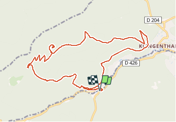

Length
12.3 km

Max alt
791 m

Uphill gradient
508 m
Km-Effort
19.1 km

Min alt
341 m

Downhill gradient
511 m
Boucle
Yes
Creation date :
2021-03-24 09:09:04.25
Updated on :
2021-04-02 16:33:51.317
3h00
Difficulty : Medium

FREE GPS app for hiking
 SityTrail
IGN / Geographical institutes
SityTrail Plus
The world is yours!
About
Trail Walking of 12.3 km to be discovered at Grand Est, Bas-Rhin, Ottrott. This trail is proposed by vaillantjm.
Description
Randonnée aisée pour une remise en jambe. Le panorama du haut de la Tour du Heidenkopf est à découvrir.
Positioning
Country:
France
Region :
Grand Est
Department/Province :
Bas-Rhin
Municipality :
Ottrott
Location:
Unknown
Start:(Dec)
Start:(UTM)
380769 ; 5368602 (32U) N.
Comments