Trail On foot Jardin - Jardin - 10,7 km - 255 m de dénivelé - 3h30 - Photo

Jardin - 10,7 km - 255 m de dénivelé - 3h30

© OpenStreetMap contributors
Length
Length
10.7 km
Max alt
Max alt
406 m
Uphill gradient
Uphill gradient
255 m
Km-Effort
Km-Effort  
14.1 km
Min alt
Min alt
276 m
Downhill gradient
Downhill gradient
256 m
Boucle
Boucle
Yes
Creation date :
2021-03-24 16:11:40.096
Updated on :
2023-12-12 12:43:23.326

(1 Reviews)

On foot
On foot
3h30
Difficulty : Medium

Scan this QR Code to open this trail in the SityTrail application

FREE GPS app for hiking

Logo SityTrail SityTrail

IGN / Geographical institutes

Download SityTrail from the App Store Download SityTrail from Google Play

Logo SityTrail SityTrail World

The world is yours!

Download SityTrail from the App Store Download SityTrail from Google Play Download SityTrail on Huawei AppGallery

About

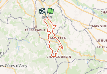
Trail On foot of 10.7 km to be discovered at Auvergne-Rhône-Alpes, Isère, Jardin. This trail is proposed by Clubléorando.

Description

Balade en boucle au départ du parking de la salle polyvalente du village de Jardin

Elevation profile

Positioning

Country:
France
Region :
Auvergne-Rhône-Alpes
Department/Province :
Isère
Municipality :
Jardin
Location:
Unknown
Start:(UTM)
649054 ; 5039794 (31T) N.

Comments

Please log in to post a review or rate the element


Trails nearby

Trail Mountain bike Les Côtes-d'Arey - Autour des Cotes d'Arey - Photo
Mountain bike
marc6262

Mountain bike

Difficult
(2)
Les Côtes-d'Arey, Auvergne-Rhône-Alpes, Isère, France
20 km | 26 km-effort
Unknown
Yes
Trail Hybrid bike Vienne - ViaRhona Vienne Coux 150km - Photo
Hybrid bike
GUIDE
thonyc

Hybrid bike

Medium
Vienne, Auvergne-Rhône-Alpes, Isère, France
146 km | 162 km-effort
Unknown
No
Trail Walking Vienne - 38-Vienne-visite-4.5km-mai21 - Photo
Walking
SyMA

Walking

Easy
Vienne, Auvergne-Rhône-Alpes, Isère, France
4.6 km | 5.2 km-effort
1h 47min
Yes
Trail Cycle Vienne - Via Rhona : Vienne St Rambert d'Albon  - Photo
Cycle
Toune73

Cycle

Very easy
(1)
Vienne, Auvergne-Rhône-Alpes, Isère, France
36 km | 39 km-effort
Unknown
No
Trail Walking Vienne - 2023-10-08 - St Alban les Vignes - La Balme -  Les Barres - Photo
Walking
beaufortchop

Walking

Easy
Vienne, Auvergne-Rhône-Alpes, Isère, France
16.4 km | 24 km-effort
4h 53min
Yes
Trail Walking Vienne - naïade nocturne digestive à Vienne - Isère - Photo
Walking
stef789

Walking

Very easy
Vienne, Auvergne-Rhône-Alpes, Isère, France
3 km | 3.6 km-effort
1h 38min
Yes
Trail Road bike Pont-Évêque - Pont-Évêque 47km - Photo
Road bike
sebcastella

Road bike

Very difficult
Pont-Évêque, Auvergne-Rhône-Alpes, Isère, France
47 km | 56 km-effort
3h 23min
Yes
Trail On foot Vienne - Vossères - Croix des Chasseurs - fixme - Photo
On foot
PRO

On foot

Easy
Vienne, Auvergne-Rhône-Alpes, Isère, France
4.4 km | 5.5 km-effort
1h 15min
No
Trail On foot Vienne - Vienne est - les hauts par St Alban les Vignes - 10,1 km - 290 m de dénivelé - 3h30 - Photo
On foot
Clubléorando

On foot

Medium
Vienne, Auvergne-Rhône-Alpes, Isère, France
10.1 km | 14 km-effort
3h 30min
Yes


Close
My subscriptions