


"Nans les pins" les sources de l'Huveaune

boulinevelyne
User
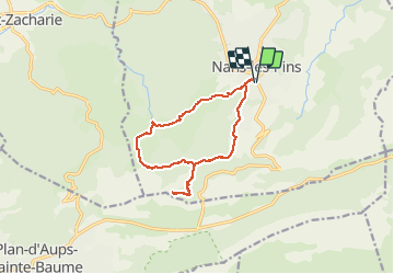

Length
13.7 km

Max alt
601 m

Uphill gradient
458 m
Km-Effort
19.8 km

Min alt
394 m

Downhill gradient
457 m
Boucle
Yes
Creation date :
2021-03-25 08:07:03.736
Updated on :
2025-03-24 13:55:44.708
5h19
Difficulty : Easy

FREE GPS app for hiking
 SityTrail
IGN / Geographical institutes
SityTrail Plus
The world is yours!
About
Trail Walking of 13.7 km to be discovered at Provence-Alpes-Côte d'Azur, Var, Nans-les-Pins. This trail is proposed by boulinevelyne.
Positioning
Country:
France
Region :
Provence-Alpes-Côte d'Azur
Department/Province :
Var
Municipality :
Nans-les-Pins
Location:
Unknown
Start:(Dec)
Start:(UTM)
725563 ; 4805589 (31T) N.
Comments