Trail Horseback riding Wintzenheim-Kochersberg - Circuit SA Wintzenheim - Oberhaslach - Photo

Circuit SA Wintzenheim - Oberhaslach

Promouvoir le Tourisme Equestre en Alsace GUIDE+
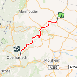
© OpenStreetMap contributors
Length
Length
26 km
Max alt
Max alt
431 m
Uphill gradient
Uphill gradient
624 m
Km-Effort
Km-Effort  
34 km
Min alt
Min alt
194 m
Downhill gradient
Downhill gradient
567 m
Boucle
Boucle
No
Creation date :
2015-08-25 00:00:00.0
Updated on :
2019-01-10 23:16:21.183

(0 Reviews)

Horseback riding
Horseback riding
4h15
Difficulty : Difficult

Scan this QR Code to open this trail in the SityTrail application

FREE GPS app for hiking

Logo SityTrail SityTrail

IGN / Geographical institutes

Download SityTrail from the App Store Download SityTrail from Google Play

Logo SityTrail SityTrail Plus

The world is yours!

Download SityTrail from the App Store Download SityTrail from Google Play Download SityTrail on Huawei AppGallery

About

Trail Horseback riding of 26 km to be discovered at Grand Est, Bas-Rhin, Wintzenheim-Kochersberg. This trail is proposed by Tourisme Equestre Alsace.

Elevation profile

Photos

Points of interest

Point of interest Wasselonne - Brechlingen - Photo
Tourisme Equestre Alsace
WASSELONNE 
Point of interest Still - Croix de Saverne - Photo
Tourisme Equestre Alsace
Point of interest Westhoffen - Le Relais du Geisweg - Photo
Tourisme Equestre Alsace
Point of interest Balbronn - Maison Forestiere Elmersforst - Photo
Tourisme Equestre Alsace
Point of interest Hohengœft - Chapelle de Hohengoeft - Photo
Tourisme Equestre Alsace
Point of interest Westhoffen - Gloriette Geierstein - Photo
Tourisme Equestre Alsace

Positioning

Country:
France
Region :
Grand Est
Department/Province :
Bas-Rhin
Municipality :
Wintzenheim-Kochersberg
Location:
Unknown
Start:(UTM)
390519 ; 5390564 (32U) N.


Close
My subscriptions