


rougiers version 3

clintest
User
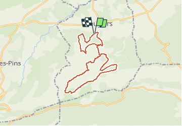

Length
16.7 km

Max alt
679 m

Uphill gradient
561 m
Km-Effort
24 km

Min alt
399 m

Downhill gradient
573 m
Boucle
Yes
Creation date :
2021-03-25 20:51:58.904
Updated on :
2021-03-25 20:52:30.8
5h30
Difficulty : Medium

FREE GPS app for hiking
 SityTrail
IGN / Geographical institutes
SityTrail Plus
The world is yours!
About
Trail On foot of 16.7 km to be discovered at Provence-Alpes-Côte d'Azur, Var, Rougiers. This trail is proposed by clintest.
Positioning
Country:
France
Region :
Provence-Alpes-Côte d'Azur
Department/Province :
Var
Municipality :
Rougiers
Location:
Unknown
Start:(Dec)
Start:(UTM)
730718 ; 4807788 (31T) N.
Comments