Trail Horseback riding Obersteinbach - Chemin Chateaux 00 Obersteinbach Boucle - Photo

Chemin Chateaux 00 Obersteinbach Boucle

Promouvoir le Tourisme Equestre en Alsace GUIDE+
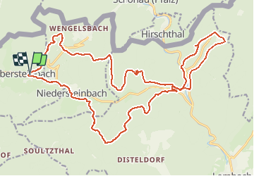
© OpenStreetMap contributors
Length
Length
27 km
Max alt
Max alt
415 m
Uphill gradient
Uphill gradient
735 m
Km-Effort
Km-Effort  
36 km
Min alt
Min alt
198 m
Downhill gradient
Downhill gradient
736 m
Boucle
Boucle
Yes
Creation date :
2021-03-26 14:53:05.477
Updated on :
2021-03-26 14:57:08.811

(0 Reviews)

Horseback riding
Horseback riding
4h46
Difficulty : Difficult

Scan this QR Code to open this trail in the SityTrail application

FREE GPS app for hiking

Logo SityTrail SityTrail

IGN / Geographical institutes

Download SityTrail from the App Store Download SityTrail from Google Play

Logo SityTrail SityTrail Plus

The world is yours!

Download SityTrail from the App Store Download SityTrail from Google Play Download SityTrail on Huawei AppGallery

About

Trail Horseback riding of 27 km to be discovered at Grand Est, Bas-Rhin, Obersteinbach. This trail is proposed by Tourisme Equestre Alsace.

Elevation profile

Photos

Points of interest

Point of interest Obersteinbach - Arnsbourg - Incontournable - Photo
Tourisme Equestre Alsace
Point of interest Niedersteinbach - WASIGENSTEIN - Incontournable - Photo
Tourisme Equestre Alsace
Point of interest Lembach - FROENSBOURG - Incontournable - Photo
Tourisme Equestre Alsace
Point of interest Lembach - Château du Fleckenstein - Photo
Tourisme Equestre Alsace
Point of interest Wingen - Château du Loewenstein - Photo
Tourisme Equestre Alsace
Point of interest Niedersteinbach - Au Cheval Blanc - Photo
Tourisme Equestre Alsace
NIEDERSTEINBACH 

Positioning

Country:
France
Region :
Grand Est
Department/Province :
Bas-Rhin
Municipality :
Obersteinbach
Location:
Unknown
Start:(UTM)
404364 ; 5432306 (32U) N.


Close
My subscriptions