


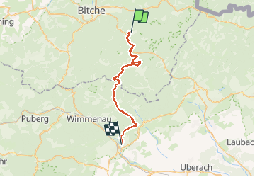
Chemin Chateaux 02 Eguelshardt Ingwiller

Tourisme Equestre Alsace
Promouvoir le Tourisme Equestre en Alsace GUIDE+

Length
31 km

Max alt
382 m

Uphill gradient
739 m
Km-Effort
41 km

Min alt
185 m

Downhill gradient
827 m
Boucle
No
Creation date :
2021-03-26 15:02:48.037
Updated on :
2021-03-26 15:04:52.743
5h26
Difficulty : Very difficult

FREE GPS app for hiking
 SityTrail
IGN / Geographical institutes
SityTrail Plus
The world is yours!
About
Trail Horseback riding of 31 km to be discovered at Grand Est, Moselle, Éguelshardt. This trail is proposed by Tourisme Equestre Alsace.
Photos


Positioning
Country:
France
Region :
Grand Est
Department/Province :
Moselle
Municipality :
Éguelshardt
Location:
Unknown
Start:(Dec)
Start:(UTM)
390592 ; 5431089 (32U) N.
Comments