


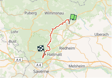
Chemin Chateaux 03 Ingwiller ErnolsheimLesSaverne

Tourisme Equestre Alsace
Promouvoir le Tourisme Equestre en Alsace GUIDE+

Length
28 km

Max alt
414 m

Uphill gradient
794 m
Km-Effort
38 km

Min alt
179 m

Downhill gradient
760 m
Boucle
No
Creation date :
2021-03-26 15:05:49.0
Updated on :
2021-03-26 15:07:33.456
5h03
Difficulty : Difficult

FREE GPS app for hiking
 SityTrail
IGN / Geographical institutes
SityTrail Plus
The world is yours!
About
Trail Horseback riding of 28 km to be discovered at Grand Est, Bas-Rhin, Ingwiller. This trail is proposed by Tourisme Equestre Alsace.
Photos


Positioning
Country:
France
Region :
Grand Est
Department/Province :
Bas-Rhin
Municipality :
Ingwiller
Location:
Unknown
Start:(Dec)
Start:(UTM)
389015 ; 5415109 (32U) N.
Comments