


Chemin Chateaux 06 Oberhaslach Mollkirch

Tourisme Equestre Alsace
Promouvoir le Tourisme Equestre en Alsace GUIDE+
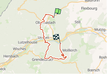

Length
22 km

Max alt
563 m

Uphill gradient
641 m
Km-Effort
31 km

Min alt
230 m

Downhill gradient
702 m
Boucle
No
Creation date :
2021-03-26 15:12:14.044
Updated on :
2021-03-26 15:13:04.341
4h00
Difficulty : Medium

FREE GPS app for hiking
 SityTrail
IGN / Geographical institutes
SityTrail Plus
The world is yours!
About
Trail Horseback riding of 22 km to be discovered at Grand Est, Bas-Rhin, Oberhaslach. This trail is proposed by Tourisme Equestre Alsace.
Photos


Positioning
Country:
France
Region :
Grand Est
Department/Province :
Bas-Rhin
Municipality :
Oberhaslach
Location:
Unknown
Start:(Dec)
Start:(UTM)
378182 ; 5379519 (32U) N.
Comments