


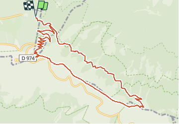
SityTrail - Ventoux

bernir
User

Length
13 km

Max alt
1889 m

Uphill gradient
618 m
Km-Effort
21 km

Min alt
1400 m

Downhill gradient
618 m
Boucle
Yes
Creation date :
2021-03-27 10:49:21.074
Updated on :
2021-03-27 11:00:00.759
4h48
Difficulty : Very difficult

FREE GPS app for hiking
 SityTrail
IGN / Geographical institutes
SityTrail Plus
The world is yours!
About
Trail Walking of 13 km to be discovered at Provence-Alpes-Côte d'Azur, Vaucluse, Beaumont-du-Ventoux. This trail is proposed by bernir.
Description
par la station de Mont Serein
Positioning
Country:
France
Region :
Provence-Alpes-Côte d'Azur
Department/Province :
Vaucluse
Municipality :
Beaumont-du-Ventoux
Location:
Unknown
Start:(Dec)
Start:(UTM)
682199 ; 4894895 (31T) N.
Comments