


VTT Cath 29km Plancenoit-Glabais-Promelles

Basile Bas
User
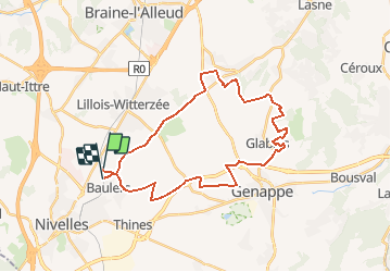

Length
29 km

Max alt
153 m

Uphill gradient
326 m
Km-Effort
33 km

Min alt
103 m

Downhill gradient
327 m
Boucle
No
Creation date :
2021-03-27 10:59:50.807
Updated on :
2021-03-28 15:14:09.446
52m
Difficulty : Easy

FREE GPS app for hiking
 SityTrail
IGN / Geographical institutes
SityTrail Plus
The world is yours!
About
Trail Mountain bike of 29 km to be discovered at Wallonia, Walloon Brabant, Nivelles. This trail is proposed by Basile Bas.
Positioning
Country:
Belgium
Region :
Wallonia
Department/Province :
Walloon Brabant
Municipality :
Nivelles
Location:
Baulers
Start:(Dec)
Start:(UTM)
595527 ; 5608495 (31U) N.
Comments