


ta erny blues

bendoush
User
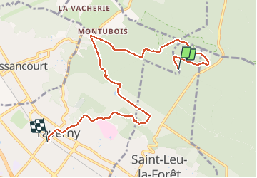

Length
8.1 km

Max alt
192 m

Uphill gradient
91 m
Km-Effort
9.7 km

Min alt
88 m

Downhill gradient
184 m
Boucle
No
Creation date :
2021-03-27 13:56:43.549
Updated on :
2021-03-27 15:51:01.375
1h53
Difficulty : Easy

FREE GPS app for hiking
 SityTrail
IGN / Geographical institutes
SityTrail Plus
The world is yours!
About
Trail Walking of 8.1 km to be discovered at Ile-de-France, Val-d'Oise, Saint-Leu-la-Forêt. This trail is proposed by bendoush.
Positioning
Country:
France
Region :
Ile-de-France
Department/Province :
Val-d'Oise
Municipality :
Saint-Leu-la-Forêt
Location:
Unknown
Start:(Dec)
Start:(UTM)
445381 ; 5431804 (31U) N.
Comments