


2021-03-27_19h01m58_VTT Froidchapelle 19.02.2012
© OpenStreetMap contributors


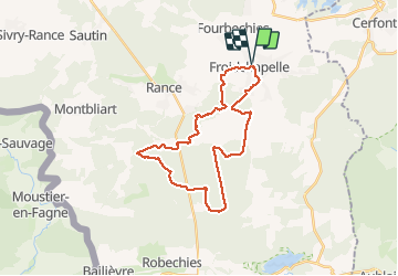
Length
26 km
Max alt
286 m
Uphill gradient
383 m
Km-Effort
31 km
Min alt
217 m
Downhill gradient
383 m
Boucle
Yes
Creation date :
2021-03-27 18:02:01.662
Updated on :
2021-03-27 18:02:01.752
FREE GPS app for hiking
 SityTrail
IGN / Geographical institutes
SityTrail Plus
The world is yours!
About
Trail of 26 km to be discovered at Wallonia, Hainaut, Froidchapelle. This trail is proposed by frederic.lorimier@skynet.be.
Positioning
Country:
Belgium
Region :
Wallonia
Department/Province :
Hainaut
Municipality :
Froidchapelle
Location:
Froid-Chapelle
Start:(Dec)
Start:(UTM)
594896 ; 5556401 (31U) N.
Comments