


2021-03-27_21h50m50_VTT Beignée 11.03.2012
© OpenStreetMap contributors


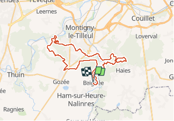
Length
31 km
Max alt
233 m
Uphill gradient
554 m
Km-Effort
39 km
Min alt
111 m
Downhill gradient
557 m
Boucle
Yes
Creation date :
2021-03-27 20:50:55.32
Updated on :
2021-03-27 20:50:56.061
FREE GPS app for hiking
 SityTrail
IGN / Geographical institutes
SityTrail Plus
The world is yours!
About
Trail of 31 km to be discovered at Wallonia, Hainaut, Ham-sur-Heure-Nalinnes. This trail is proposed by frederic.lorimier@skynet.be.
Positioning
Country:
Belgium
Region :
Wallonia
Department/Province :
Hainaut
Municipality :
Ham-sur-Heure-Nalinnes
Location:
Ham-sur-Heure
Start:(Dec)
Start:(UTM)
599514 ; 5576593 (31U) N.
Comments