


gpx-trace

bubuserge
User
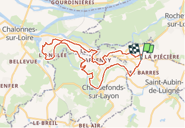

Length
18.8 km

Max alt
90 m

Uphill gradient
283 m
Km-Effort
23 km

Min alt
11 m

Downhill gradient
281 m
Boucle
Yes
Creation date :
2021-03-30 13:44:39.154
Updated on :
2021-03-30 16:41:49.316
5h07
Difficulty : Very difficult

FREE GPS app for hiking
 SityTrail
IGN / Geographical institutes
SityTrail Plus
The world is yours!
About
Trail Walking of 18.8 km to be discovered at Pays de la Loire, Maine-et-Loire, Val-du-Layon. This trail is proposed by bubuserge.
Positioning
Country:
France
Region :
Pays de la Loire
Department/Province :
Maine-et-Loire
Municipality :
Val-du-Layon
Location:
Saint-Aubin-de-Luigné
Start:(Dec)
Start:(UTM)
675145 ; 5245490 (30T) N.
Comments