


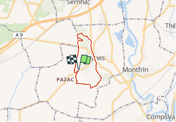
Meynes - bois-de-clausonne

rando30129
User

Length
9.5 km

Max alt
75 m

Uphill gradient
74 m
Km-Effort
10.5 km

Min alt
28 m

Downhill gradient
74 m
Boucle
Yes
Creation date :
2021-03-30 11:26:44.242
Updated on :
2021-05-16 09:24:41.182
2h09
Difficulty : Medium

FREE GPS app for hiking
 SityTrail
IGN / Geographical institutes
SityTrail Plus
The world is yours!
About
Trail Walking of 9.5 km to be discovered at Occitania, Gard, Meynes. This trail is proposed by rando30129.
Positioning
Country:
France
Region :
Occitania
Department/Province :
Gard
Municipality :
Meynes
Location:
Unknown
Start:(Dec)
Start:(UTM)
624654 ; 4859262 (31T) N.
Comments