


3103

maxEA65
User
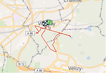

Length
7.3 km

Max alt
182 m

Uphill gradient
170 m
Km-Effort
9.5 km

Min alt
113 m

Downhill gradient
170 m
Boucle
Yes
Creation date :
2021-03-31 12:44:22.487
Updated on :
2021-03-31 14:30:53.28
1h38
Difficulty : Medium

FREE GPS app for hiking
 SityTrail
IGN / Geographical institutes
SityTrail Plus
The world is yours!
About
Trail Walking of 7.3 km to be discovered at Ile-de-France, Yvelines, Viroflay. This trail is proposed by maxEA65.
Positioning
Country:
France
Region :
Ile-de-France
Department/Province :
Yvelines
Municipality :
Viroflay
Location:
Unknown
Start:(Dec)
Start:(UTM)
439216 ; 5405267 (31U) N.
Comments