


Vercors tourbière du Peuil

c.gourme
User
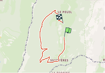

Length
7.6 km

Max alt
1200 m

Uphill gradient
372 m
Km-Effort
12.6 km

Min alt
859 m

Downhill gradient
365 m
Boucle
No
Creation date :
2021-04-01 07:32:16.0
Updated on :
2024-11-12 17:07:45.358
2h59
Difficulty : Very easy

FREE GPS app for hiking
 SityTrail
IGN / Geographical institutes
SityTrail Plus
The world is yours!
About
Trail Walking of 7.6 km to be discovered at Auvergne-Rhône-Alpes, Isère, Claix. This trail is proposed by c.gourme.
Description
Il y a une possibilité de piqueniquer à l'abri à Le Punais dans une ferme qui se situe un peu après la bifurcation à droite qui nous emmène le long de la tourbière.
Positioning
Country:
France
Region :
Auvergne-Rhône-Alpes
Department/Province :
Isère
Municipality :
Claix
Location:
Unknown
Start:(Dec)
Start:(UTM)
708189 ; 4999282 (31T) N.
Comments