


peuil

Liebeaux
User
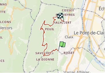

Length
13.3 km

Max alt
1111 m

Uphill gradient
816 m
Km-Effort
24 km

Min alt
378 m

Downhill gradient
747 m
Boucle
No
Creation date :
2021-04-01 07:46:14.597
Updated on :
2021-04-01 13:47:19.786
5h59
Difficulty : Very easy

FREE GPS app for hiking
 SityTrail
IGN / Geographical institutes
SityTrail Plus
The world is yours!
About
Trail Walking of 13.3 km to be discovered at Auvergne-Rhône-Alpes, Isère, Claix. This trail is proposed by Liebeaux.
Positioning
Country:
France
Region :
Auvergne-Rhône-Alpes
Department/Province :
Isère
Municipality :
Claix
Location:
Unknown
Start:(Dec)
Start:(UTM)
709268 ; 4998433 (31T) N.
Comments