


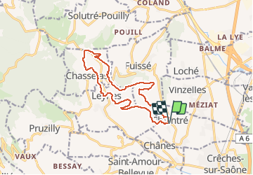
Chantré (Saône et Loire)

Thomasdanielle
User

Length
13.8 km

Max alt
418 m

Uphill gradient
349 m
Km-Effort
18.5 km

Min alt
244 m

Downhill gradient
350 m
Boucle
Yes
Creation date :
2021-04-01 08:25:36.0
Updated on :
2021-04-06 10:02:18.974
5h37
Difficulty : Medium

FREE GPS app for hiking
 SityTrail
IGN / Geographical institutes
SityTrail Plus
The world is yours!
About
Trail Walking of 13.8 km to be discovered at Bourgogne-Franche-Comté, Saône-et-Loire, Chaintré. This trail is proposed by Thomasdanielle.
Description
D/A : Parking Église (14 km - D. 349 m)
Photos
 - Photo 1")
 - Photo 2")
 - Photo 3")
Positioning
Country:
France
Region :
Bourgogne-Franche-Comté
Department/Province :
Saône-et-Loire
Municipality :
Chaintré
Location:
Unknown
Start:(Dec)
Start:(UTM)
635616 ; 5124452 (31T) N.
Comments