


Montrouvard

repiton
User
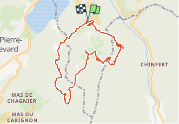

Length
13.2 km

Max alt
1166 m

Uphill gradient
564 m
Km-Effort
21 km

Min alt
778 m

Downhill gradient
566 m
Boucle
Yes
Creation date :
2021-04-01 07:32:48.864
Updated on :
2021-04-01 16:39:13.81
5h20
Difficulty : Very difficult

FREE GPS app for hiking
 SityTrail
IGN / Geographical institutes
SityTrail Plus
The world is yours!
About
Trail Walking of 13.2 km to be discovered at Auvergne-Rhône-Alpes, Isère, Allevard. This trail is proposed by repiton.
Positioning
Country:
France
Region :
Auvergne-Rhône-Alpes
Department/Province :
Isère
Municipality :
Allevard
Location:
Unknown
Start:(Dec)
Start:(UTM)
271006 ; 5029298 (32T) N.
Comments