


st Pierre de chandieu 9.4 a269 g1 d9.5

jtraverse
User
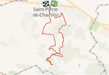

Length
9.4 km

Max alt
366 m

Uphill gradient
270 m
Km-Effort
13 km

Min alt
256 m

Downhill gradient
270 m
Boucle
Yes
Creation date :
2021-04-02 10:40:46.244
Updated on :
2021-04-02 13:36:36.277
2h54
Difficulty : Difficult

FREE GPS app for hiking
 SityTrail
IGN / Geographical institutes
SityTrail Plus
The world is yours!
About
Trail Walking of 9.4 km to be discovered at Auvergne-Rhône-Alpes, Rhône, Saint-Pierre-de-Chandieu. This trail is proposed by jtraverse.
Positioning
Country:
France
Region :
Auvergne-Rhône-Alpes
Department/Province :
Rhône
Municipality :
Saint-Pierre-de-Chandieu
Location:
Unknown
Start:(Dec)
Start:(UTM)
656814 ; 5056611 (31T) N.
Comments