les canalettes

hvezinet
User
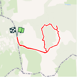

Length
7.5 km

Max alt
737 m

Uphill gradient
107 m
Km-Effort
9 km

Min alt
676 m

Downhill gradient
107 m
Boucle
Yes
Creation date :
2014-12-10 00:00:00.0
Updated on :
2014-12-10 00:00:00.0
1h59
Difficulty : Easy

FREE GPS app for hiking
 SityTrail
IGN / Geographical institutes
SityTrail Plus
The world is yours!
About
Trail Walking of 7.5 km to be discovered at Occitania, Aveyron, Nant. This trail is proposed by hvezinet.
Description
difficile de decrire l'acces aux canalettes. des marques rouges sur les arbres et des cairns indiquent les acces. le sentier jusqu"à la maison forestiere est par endroit juste visible mais existe bien.


Positioning
Country:
France
Region :
Occitania
Department/Province :
Aveyron
Municipality :
Nant
Location:
Unknown
Start:(Dec)
Start:(UTM)
518927 ; 4869458 (31T) N.
Comments