


CAL LES AIGUIERES

poisson1103
User
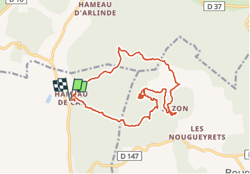

Length
11 km

Max alt
291 m

Uphill gradient
330 m
Km-Effort
15.4 km

Min alt
143 m

Downhill gradient
330 m
Boucle
Yes
Creation date :
2021-04-02 08:25:20.329
Updated on :
2022-01-20 12:26:22.204
5h04
Difficulty : Medium

FREE GPS app for hiking
 SityTrail
IGN / Geographical institutes
SityTrail Plus
The world is yours!
About
Trail Walking of 11 km to be discovered at Occitania, Gard, Navacelles. This trail is proposed by poisson1103.
Photos


41 photos in total. Please click on a photo to see them all in the gallery.
Positioning
Country:
France
Region :
Occitania
Department/Province :
Gard
Municipality :
Navacelles
Location:
Unknown
Start:(Dec)
Start:(UTM)
599032 ; 4892300 (31T) N.
Comments