


Blaesheim tour de klokensbrg

apa
User
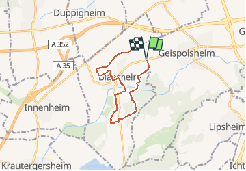

Length
10.4 km

Max alt
196 m

Uphill gradient
101 m
Km-Effort
11.7 km

Min alt
143 m

Downhill gradient
101 m
Boucle
Yes
Creation date :
2021-04-03 05:54:00.722
Updated on :
2021-04-03 05:55:54.718
2h39
Difficulty : Medium
--
Difficulty : Very easy

FREE GPS app for hiking
 SityTrail
IGN / Geographical institutes
SityTrail Plus
The world is yours!
About
Trail Walking of 10.4 km to be discovered at Grand Est, Bas-Rhin, Blaesheim. This trail is proposed by apa.
Positioning
Country:
France
Region :
Grand Est
Department/Province :
Bas-Rhin
Municipality :
Blaesheim
Location:
Unknown
Start:(Dec)
Start:(UTM)
398357 ; 5374181 (32U) N.
Comments