


tour de gael

PatriceCocuaud
User

Length
21 km

Max alt
436 m

Uphill gradient
352 m
Km-Effort
26 km

Min alt
296 m

Downhill gradient
350 m
Boucle
Yes
Creation date :
2021-04-03 08:30:41.129
Updated on :
2021-04-03 12:46:02.787
2h20
Difficulty : Easy

FREE GPS app for hiking
 SityTrail
IGN / Geographical institutes
SityTrail Plus
The world is yours!
About
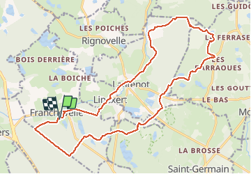
Trail Mountain bike of 21 km to be discovered at Bourgogne-Franche-Comté, Haute-Saône, Franchevelle. This trail is proposed by PatriceCocuaud.
Positioning
Country:
France
Region :
Bourgogne-Franche-Comté
Department/Province :
Haute-Saône
Municipality :
Franchevelle
Location:
Unknown
Start:(Dec)
Start:(UTM)
309595 ; 5290321 (32T) N.
Comments