


20210303-Waterloo

marcelberman
User
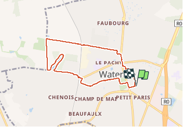

Length
7.4 km

Max alt
130 m

Uphill gradient
82 m
Km-Effort
8.5 km

Min alt
96 m

Downhill gradient
82 m
Boucle
Yes
Creation date :
2021-04-03 12:52:16.0
Updated on :
2021-04-03 14:31:06.435
1h39
Difficulty : Very easy

FREE GPS app for hiking
 SityTrail
IGN / Geographical institutes
SityTrail Plus
The world is yours!
About
Trail Walking of 7.4 km to be discovered at Wallonia, Walloon Brabant, Waterloo. This trail is proposed by marcelberman.
Description
Bous de Bruyères, chemin des cochons
Positioning
Country:
Belgium
Region :
Wallonia
Department/Province :
Walloon Brabant
Municipality :
Waterloo
Location:
Waterloo
Start:(Dec)
Start:(UTM)
599028 ; 5618838 (31U) N.
Comments