


Pavie

Pascal Bernaud
User
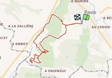

Length
10.8 km

Max alt
213 m

Uphill gradient
248 m
Km-Effort
14.1 km

Min alt
139 m

Downhill gradient
248 m
Boucle
Yes
Creation date :
2021-04-03 12:09:36.0
Updated on :
2021-04-03 15:15:52.99
3h04
Difficulty : Difficult

FREE GPS app for hiking
 SityTrail
IGN / Geographical institutes
SityTrail Plus
The world is yours!
About
Trail Walking of 10.8 km to be discovered at Occitania, Gers, Pavie. This trail is proposed by Pascal Bernaud.
Positioning
Country:
France
Region :
Occitania
Department/Province :
Gers
Municipality :
Pavie
Location:
Unknown
Start:(Dec)
Start:(UTM)
305350 ; 4830938 (31T) N.
Comments